Commercial Drone Property Photography FAA Part 107 Anniston, Alabama

Commercial Drone Property Photography FAA Part 107 Anniston, Alabama

Compliance-Driven Operations
FAA Part 107 certified operator
Fully licensed and insured
Airspace authorization when required
Repeatable capture methods for consistency
Saks Drone Services operates with a strong emphasis on regulatory compliance and professional standards. Our services are designed for organizations that require licensed, insured, and FAA-compliant vendors.
Experience and Reliability
Saks Drone Services has provided ongoing aerial and ground photography services for commercial property firms, including long-term contracts with out-of-state organizations. Our clients rely on us for consistent delivery, clear communication, and dependable scheduling.

Who needs this service?
Developers and construction firms
Insurance, Facilities, Operations & Risk Management Firms
Out-of-area owners requiring remote site visibility
Examples:
Saks Drone Services works with organizations that require reliable, compliant visual documentation for commercial and investment properties. Our clients value consistency, accuracy, and professional standards.
Commercial Visual Documentation Services
Provide non-invasive aerial and ground photography captured for documentation, reporting, and professional use. All imagery is delivered with consistent framing and clarity to support internal records, marketing materials, and third-party review.

Exterior structure and site photography
Parking areas, access points, signage, and improvements
Consistent angles for repeat documentation
High-resolution drone imagery
FAA-authorized flights when required
Site overviews, roof visibility, surrounding context
Saks Drone Services provides aerial and ground photography for property documentation and visual updates. Imagery is captured strictly for record-keeping, reporting, and client review and does not constitute inspection, evaluation, or professional judgment.
Aerial perspective before updates
Aerial perspective after updates
Out-of-state investors, REITs, and property managers rely on accurate, up-to-date visuals to protect their commercial property assets. Saks Drone Services provides non-invasive aerial and ground photography for property documentation and visual updates. Imagery is captured strictly for record-keeping, reporting, and client review and does not constitute inspection, evaluation, or professional judgment.
From roof conditions and parking lot striping to façade updates and site improvements, our high-resolution imagery delivers clear, objective insight into your investment, helping you verify work quality, track progress, and maintain accountability. See your property clearly. Manage confidently—no matter where you are.
Ground level oblique Photo of a medical clinic
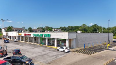
Aerial drone perspective of a shopping plaza

• Scheduled visual updates
• Before / during / after imagery
• Remote visibility for stakeholders

Parking Lot Before Renovation
Parking Lot After Renovation
Parking Lot After Renovation
Parking Lot Renovation Details
Parking Lot Renovation Details
Parking Lot Renovation Details
![]() Steve W.0 friends9 reviews2 photos10/21/25
Steve W.0 friends9 reviews2 photos10/21/25
Philip was super responsive and got me a weekend slot so that I could hit my deadline. Photos came out great!
Michael Roy
Local Guide • 52 reviews • 10 photos
starstarstarstarstar Mar 22, 2024
We use Philip monthly for our commercial properties. His services are invaluable, his prices fair, and his work is professional. Can't recommend him enough.
Chris Wells
2 reviews • 0 photos2 reviews • 0 photos
starstarstarstarstar Mar 13, 2023
We were exceptionally pleased with the drone video footage taken at our location (Wells Septic Tank, Inc.). Good folks to work with
Top Storage
5 reviews • 1 photo
starstarstarstarstar Mar 5, 2023
Philip was great to work with. He complete the photos quickly and very reasonably priced. Highly recommend using Philip for any photography needs!
Milton Harris
1 review • 0 photos
starstarstarstarstar Mar 4, 2023
Phillip did an excellent job of aerial photos from his drone of pickleball courts for our church. He was very professional and timely getting shots taken to our email. He has a gift of making great videos and still shots from his drones. I would highly recommend his services and definitely will use him in the future. Milton Harris with Hill Crest Baptist Church in Anniston, AL
John Moore
Local Guide • 24 reviews • 0 photos
starstarstarstarstar 37 weeks ago
Highly professional operators
Stephen Anthony
1 review • 0 photos
starstarstarstarstar Mar 4, 2023
Great pics and video of our home. Phil did awesome job and was so prompt at working complete video process. Editing was done quickly and very professional. Shows the beauty and surroundings of our property


